
Noted surrealist painter Réné Magritte was Belgian. It is perhaps appropriate that Belgian politics produced a surreal Métro line, that is neither a metro nor operational. But that is about to change, in Charleroi.
This is the illustrated story of Belgium's most bizarre public transport network, and possibly one of the strangest in the world. Recently it was announced that, after decades of neglect, the Charleroi Métro will complete its fifth line. A thawing for a metro that seemed frozen in the 1980s.
Ceci n’est pas un Métro
The Charleroi Métro, as one might expect from the country of surrealism, is not really a metro. Rather, with its tram stock, it's either a light metro or light rail transit (LRT). It all started in the 1960s. Belgium planned five major metros for its largest cities - Brussels, Antwerpen, Ghent, Liège, and Charleroi. Local issues in Ghent and Liège caused them to refuse their metros, and their funds were then reallocated to Antwerpen and Charleroi.
At this time, the central Belgian state drafted plans, but the budget had to be balanced between Flanders (north) and Wallonia (south) in a 50/50 ratio, called "Wafelijzerpolitiek". This literally translates as "waffle-iron politics" - the idea that a waffle-iron leaves an identical impression on both sides of waffle - both sides of the iron are necessary to make the local delicacy. So if a project was funded in Flanders, a similar project also had to be funded in Wallonia, regardless of the actual need.
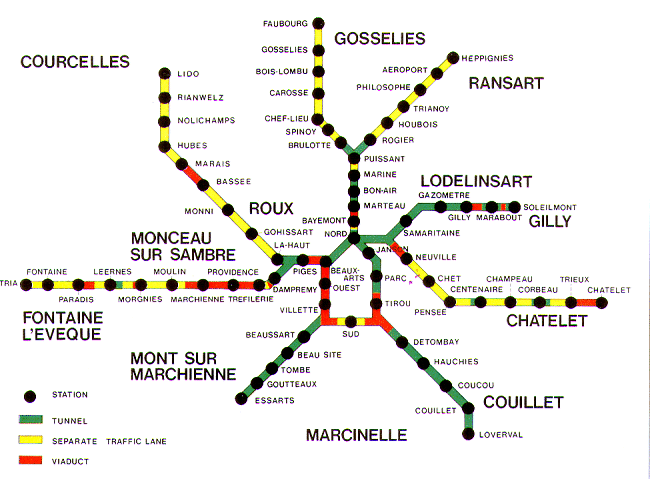
That's how in the late 1960s, Charleroi was approved for a metro network of eight (8) branches, perhaps a bit too ambitious for a city of its size. Despite being the largest city in Wallonia, and the 4th largest in Belgium, it only has around 200,000 inhabitants.
What’s the deal with Belgium?
The Flanders region comprises the Flemish (Dutch) speaking provinces, with the French speaking minority Walloons primarily residing in the Wallonia provinces (and the Brussels-Capital Region). Wallonia constitutes the southern half of the country, and during the industrial revolution, it exploited its extensive deposits of coal and iron. It was second only to the UK in industrialization, which brought much wealth. However, since World War II, heavy industry has greatly diminished, and Wallonia’s smaller population now suffers from high unemployment and lower GDP per capita than Flanders. The two regions’ economic disparity, the Wallonian minority population, and the linguistic difference, are major sources of political tension in Belgium.
What is a Vicinal?
Construction of Belgium's rural tramways started in 1875, with the creation of a nationwide operator - Maatschappij van Buurtspoorwegen (NMVB) in Dutch, and Société nationale des chemins de fer vicinaux (SNCV) in French. However, the system and its lines were generally called ‘Vicinal’, the French word for country link. It is equivalent to the interurbans that connected towns and cities in the US and Canada in the first half of the twentieth century. The majority of the Vicinal lines were metre gauge (3 ft 3 3⁄8 in), and operated both passenger and freight trams. The non-electric network peaked at 3,938 kilometres (2,447 mi) in 1925, but as of buses, lorries and electric trams usage increased, non-electrified Vicinal lines started to close. Despite a much smaller electric Vicinal network, electrification continued, to peak at 1,528 kilometres (949 mi) in 1950. The whole network (electric and non-electric) was still approximately 4,236 kilometres (2,632 mi) in length (the peak of 4,811 kilometres (2,989 mi) was in 1945), but by 1960 had been reduced to only 977 kilometres (607 mi). Similar to railway branch lines, Vicinal passenger tram services were replaced by buses, but SNCV/NMVB kept running freight trams as long as they were profitable.
Today, few parts of the Vicinal network are still in operation. Segments of the Charleroi Métro have upgraded Vicinal trackage, and the Coast Tram (Kusttram in Dutch) that operates along the length of the entire Belgian coast. At 67 km it is the world's longest operating tram line. The Vicinal Tram Museum southwest of Charleroi, also on a former Vicinal route, tells the network's story.
End of the waffle
Unfortunately for the waffle lovers, the Wafelijzerpolitiek policy came to an end in 1980 as Belgian political reform saw the splitting of many national institutions into separate bodies for Flanders, Wallonia, and the Brussels-Capital Region. Accordingly, SNCV/NMVB was broken up in 1991 into De Lijn (for Flanders) and TEC (for Wallonia). Whilst both companies primarily operate buses, TEC (which stands for Transport En Commun, French for public transport) also operates the Charleroi Métro, previously called a pre-metro, and now sometimes called a Light Metro.
Soon after its inception the whole Métro project unfortunately went downhill. The city started to decay in the 1970s when a big part of its heavy industry closed down. What once was the economic powerhouse of Belgium slowly became a rust belt post-industrial city. The rest of the Métro plan was similarly outdated, even the lines that had been constructed.
This system has even been considered one of Belgium's best examples of "Great Useless Public Works" (Grands travaux inutiles). The Metro featured on the Belgian public TV channel comedy show reporting on useless projects. Warning - it's in French!

Furthermore, the eight branch network followed the urbanist principles of the time - trams would go underground or elevated, so they wouldn't disturb cars. Lines towards the suburbs would follow newly built motorways. However, this led to many stations, pretty much, in the middle of nowhere. Plus, the population did not grow – it shrank along with the city’s heavy industry. The Métro was designed with long platforms for 6 car long trams, but they will never see a tram longer than the standard 2-car unit.
Stations
Providence station is perhaps where the contrast between project and reality is best seen. A metro station in the middle of Charleroi's heavy industry zone, much of it idle. The passenger demand just isn't there anymore:

The western branch (Lines 1/2) was built first, not necessarily because of higher demand, but rather because a new motorway was being built there. It also crossed through highly industrialised areas. But the stations were near the motorway, but far away from the actual towns, and the economic decay of the 1980s meant that no new housing estates were built near the stops, as had been expected.
A couple of stops further west is Morgnies, a village with its very own metro station. And mind you, as much as this station seems like it is abandoned, it gets a tiny 2-unit 'metro train' every 15 minutes on weekdays:

Next stop, Leernes - a tram stop in the ‘finest’ 1970s brutalism style. A building that looks more like the abandoned film set for one of the early Star Wars films. This is one of the least used in the whole network. The centre of the town that it's supposed to serve is 15 minutes away by foot:


Ladies and gentlemen, welcome to Paradise. Or at least the Belgian version, in the town of Fontaine-l'Évêque. Another station built with high ambition and lots of 1970s brutalist aesthetics:

Anderlues Monument, at the end of the line. The bidirectional trams make reversing easy. Here the Métro runs on the old SNCV Vicinal tram tracks. Note the tram's retractable steps to allow street-level boarding:

Back in the central loop. Beaux-Arts, one of the stations that serve central Charleroi. It was opened in 1983, and has seen better days. It was quite dirty. The heritage tram on display at the right is not from the Vicinal, but from the separate Charleroi city tram network, operated by the company Tramways électriques du pays de Charleroi et extensions, of which no lines survive.

Next stop. Waterloo. Not quite that Waterloo, which is a town between Brussels and Charleroi. It is the Waterloo quartier in downtown Charleroi.

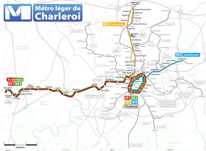
Piges station, opened in 1980. It's at the north west part of the central loop, where the M3 Gosselies line branches off from lines 1/2:

In 1992 the Gilly branch (routes 54/55) opened (now M4). In 1996 the central loop was (almost) completed with the Parc extension:

In 2013, the northern branch opened (M3). Roughly half of the route was already in use, but only for trams to reach the Jumet depot. Four decades after opening the first stations, Charleroi received the latest addition to its metro:
The Ghost Line
Notice on the original 1960s map the east-southeast Châtelet branch? It can also been seen in the current map just above as the grey hollow line extending similarly from M3 leaving the loop from Waterloo station. The first four stations - Neuville, Chet, Pensée, and Centenaire - were completed in the early 1980s, with the track and structural work finished the next two stations, Champeau and Roctiau. But the branch was judged to have little demand and funding was tight, so construction was halted and it was never opened. This is by far the most interesting section of this system.


Here is a short, recent tram cab ride video clip through a couple of these disused stations, with a surprisingly nonchalant tram driver. The French chit chat is inconsequential.
Vicinal tram gauge used
Not only does the Charleroi Metro use metre gauge track, it also has the unique platform height of 55 cms. In the 1960s, Wafelijzerpolitiek money was budgeted for infrastructure, but not for new trams. So the decision was taken to keep using the old 1950s SNCV trams to work the metro. These trams served platforms 55 cm high. So the city got stuck with its unique standard forever.
In the late 1970s, the still federal SNCV ordered a new fleet from BN trams (La Brugeoise et Nivelles, a Belgian rolling stock manufacturer, parts of which were later acquired by Bombardier and Alstom). As mentioned before, the Wafelijzerpolitiek meant that even a tram order had to adhere to the strict north/south balance. Half the trams went to Charleroi, Wallonia, and half to the Kusttram (in Flanders). Since they would have to fit both systems, a retractable step was added.
In total, 106 trams were produced and half went to each city, even though that many trams were not needed for Charleroi’s small metro. The surplus of units, linked to a general lack of control due to imminent dismantling of SNCV, led to horrible management.
By the early 1990s, when the TEC was created, 22 trams were out of service or used for parts. Thirty trams kept the network running to its bare minimum Since then, TEC started to rescue these units, but many simply rotted at depots. Fortunately, 16 of the 22 were rebuilt. Eventually these 16 + 30 trams were refurbished throughout the 1990s and 2000s. The only negative aspect was the home-made recovery method which created technologically unique trams.
Fortunately in 2018, TEC and Alstom signed a contract to fully renew 45 units. The prototype was unveiled some weeks ago and it doesn't look like a 40 years old tram.
Wouldn't new trams make more sense?
First of all, the trams were constructed to last, with robust mechanicals and simple electricals. Mainly, however, the decision to go with the 55cm platform height severely limits the rolling stock. No tram manufacturer has designs for such platform level. Worldwide, trams are either low-level (roughly 30 cm above the surface) for easy street access, or high level (+86 cm) like the German stadtbahns. So ordering 45 trams for this intermediate platform height would cost a fortune. So, for the next 20 years or so, the refurbished BN trams will keep rolling in Charleroi.
Back to the Métro léger
The network has its origins in the Vicinal interurban network, though has largely been upgraded since the 1970s. The city centre loop is primarily underground. This is the portal near Beaux-Arts station:

West of Charleroi City Centre, the line parallels the Route de Mons, passing largely derelict industry:

Shortly before Marchienne-au-Pont, the line crosses the River Sambre on a large bridge:


The walk along the parallel Sambre River is equally fascinating. There is a towpath walking and cycling route along the south side and there's still a fair amount of barge traffic:

In Anderleus, 15km west of Charleroi, there are still some vestiges of the system's interurban heritage:

And some street running along the Chaussée de Bruxelles in the north:

Strong history of the arts in Belgium
The unique architecture and public art are key aspects of the Métro, continuing a long art tradition in Belgium. Flemish painting was a major force in western European art during the Renaissance. At the turn of the twentieth century, Brussels was a major force in the development of the Art Nouveau style, a predecessor to the Art Deco and Art Moderne movements. Art Nouveau architects, most notably Victor Horta, lived and worked primarily in Brussels. Hence it is not surprising to see exuberant Metro architecture, bold colours, and expressive public art on this network.
Réné Magritte’s painting Au Revoir inspired Paul McCartney to use the apple image and name for the Beatles’ new company, Apple Corp.


Resurrection of the Ghost Line
In June 2021, Europe approved the Belgian recovery plan, of which €60 million will be allocated to extending the Charleroi Métro to the future Grand Hôpital de Charleroi (GHdC) in Gilly. Both line M5 and the abuilding largest hospital in Charleroi will serve the rapidly expanding metropolis. The new funding will enable renovation of the six existing but never opened stations, plus construction of two new ones, Corbeau and Les Viviers.

Construction of the new M5 line is scheduled start in June 2023, and is planned to enter into service in 2026, being fully accessible to people with reduced mobility.
Four of the eight branches will have been opened. Perhaps the surrealist politicians got it right in the end.
This article was taken from a tweet thread by Adrian Fuentes, who also took many of the photos. He researched and translated most of the historical and technical info from this month's edition of Tram2000 magazine (http://tram2000.be) which covers in-depth the past and future of the Charleroi Métro. Additional information and photos on the Charleroi Metro came from a tweet thread from Dr Brian Doucet. Many thanks to both for allowing me to use their work.