London's new Crossrail Network - detail - NotQuiteTangible.blogspot.com

Elizabeth Line Envy: Thameslink deserves some map respect

In an episode of Star Trek: The Next Generation, Commander Riker was challenged by a subordinate. His response was “I bring all the options to the Captain.” This needs to be one of TfL’s map design’s guiding principles: passengers need to see all the central London rail options on the Tube Map.

It was ultimately pandemic related disruption severely affecting Tube services for extended periods that caused TfL to finally relent on Thameslink’s two decade banishment. The line’s reappearance in summer 2020 was predicated on providing much needed connectivity options, quicker trips, shorter trajectories, and less Tube overcrowding for better social distancing on often less than full services across the TfL network. It should be noted that the Thameslink’s operating company Govia Thameslink Railway (GTR) has long pushed for the line to be reinstated on the Map, assisted recently by London TravelWatch. The line reinstatement also served to provide alternative routes during the Northern line Bank branch closure for the Bank station upgrade. By most accounts, Thameslink served admirably to optimise journeys and travel across London. So the initial 12 month trial period has been extended indefinitely.

Family relationship

It’s clear why TfL doesn’t want to acknowledge its step brother. It’s not that they don’t get along – they do, more than most urban railways of different parents. But the fear of Thameslink absconding with some Northern line passenger revenue led TfL’s predecessor London Regional Transport (LRT) to drop Thameslink off the Tube Map in 1999. The line had featured on London’s signature navigational diagram since the railway’s inception. It first appeared in July 1987, but only the central trunk from Kentish Town to Moorgate, London Bridge, and Elephant and Castle:

1998 Tube Map, showing part of the Thameslink trunk

The new millennium saw a new organisation, TfL, replace LRT. However, by default TfL continued with many LRT practices, and so inherited the Tube Map sans Thameslink. But TfL didn’t take positive action to change this. IanVisits has the Thamelink restoration to the Tube Map saga in more detail. Fortunately, the recent December 2020 TfL map restoration shows Thameslink services to Zones 1 to 8. This includes its services to Dartford, Bromley, Catford, Charlton, New Southgate, and Cricklewood which had never been on the Tube map before. A total of 49 additional stations have been added. As most of the added Thameslink stations are south of the river, this provides more equity in showing railway services in south London.

Central London on new Tube Map

The emergence of the new RER network has ramifications for the Tube Map. Unfortunately, the Map currently effectively de-emphasises the two these high capacity, higher speed lines. They are difficult to pick out in the above image, being less prominent than the slower and shorter, yet more visible Underground lines.

Even the Thames had been cartographically slighted

Father Thames himself was grossly slighted when he was suddenly dropped from the Tube Map in 2009, leaving Londoners aghast and confused by the loss of the map’s main navigational reference.

The Thames-less, anchorless Tube Map of 2009

Mayor Johnson had the Thames restored to the Tube Map, as even on a stylised diagram removal of the Thames was a step too far. In following years, River Bus pier interchanges with Underground stations have been discreetly added to the diagram, providing Londoners and visitors with the option of an uncrowded and much more scenic travel mode.

The mental perception of public transport geography

The aforementioned incident demonstrated that many Londoners’ and visitors’ mental map of London is based directly on the Tube Map. Another example is the London Overground network, starting with one of its component railways.

The ridership of the North London line went up when it was added, intermittently it turns out, to the Tube Map (as a hollow black line) in 1977. This also demonstrates the tendency for Londoners, and visitors, to believe that if an urban line does not appear on the Tube Map, it does not exist. Many Overground lines were added to the Map in the 2000s, featuring many such upgraded and re-opened peripheral urban lines, This increased awareness of the Overground lines tremendously, and ridership increased massively by expanding the reach of millions of Londoners on public transport. The revival of those hitherto somewhat moribund and under-utilised passenger lines and bringing them up to TfL’s signage and cleanliness standard was also a major factor. Often called the ‘Overground Effect’, it shews the enormous power an impact of adding lines to the Tube Map.

Now with Crossrail’s emergence, the capital’s public transport centre of gravity has arguably moved to Farringdon, which maximises regional mobility via Thameslink and Elizabeth lines.

As an aside, TfL had considered taking over the Northern City Line in 2016, in the report A new approach to rail passenger services in London and the South East, published jointly by TfL, DfT, and the Mayor of London in 2021. If that had occurred, there is a good chance that this line would also have been added back to the Tube Map.

Elizabeth both is, and isn’t, a Tube line

TfL constructed the Elizabeth Line to seamlessly integrate with its Tube network, in terms of operations, passenger flow, and branding. Passengers know Crossrail as a faster, roomier, more comfortable, and farther travelling line. As such, the mode of train vs tube train no longer matters – the passengers certainly don’t care. Effectively, Crossrail is a fast, large capacity Tube line.

The genesis of London’s regional express rail network

Crossrail’s opening heralds the start of the higher order, express Tube network, building on Thameslink’s success. Similar, but decades behind, the Parisian Réseau express régionale (RER) network. The Parisian equivalent opened in 1971 with the same sense of spaciousness and rapid cross-city travel. Paris now has five RER lines on various axes. Like the Elizarail Line, it also has some lengthy interchanges, which cannot always be avoided – it would cost additional billions.

Thameslink is London’s original RER opened in 1988, only 17 years after Paris. It is important to note that the original Thameslink concept, as developed by Network SouthEast, was intended as the north-south component of a regional RER network to put nearly all the major settlements in Greater London within one interchange and less than 90 minutes apart. That was the way it was sold to the politicians. And it still fulfils that role in great part today

Crossrail comes 32 years after Thameslink. Crossrail is a game changer, as Thameslink was. Passengers benefit by having Thameslink on all TfL maps and signage, by providing many more destinations, and faster trips than the Underground and Overground. Isn’t it for the passengers that public transport is operated?

Unfortunately, there is considerable lack of consensus over Crossrail 2’s route, as we examined previously. So any addition to the Capital’s regional express rail network will takes decades, despite Londoners’ enthusiasm for expanding upon Crossrail 1’s success.

Crossrail Zero inspired Crossrail 1

Thameslink is the first high capacity, mainline passenger railway passing through and serving central London. It is the de facto first Crossrail, or Crossrail 0. The north-south spine has earned its place on the Tube Map – it has greatly shrunken time and distance for millions annually.

Thameslink has many branches north and south of London. Whilst that greatly increases its coverage, the drawback is that a delay on one branch can adversely affect a number of others. Crossrail designers learned much from its predecessor, opting for the much simpler two branches on either side of central London for greater reliability.

Now with Crossrail finally opening, London will have high capacity, limited stop express metros in all four cardinal directions. The two routes complement each other well. In networks, the sum is much greater than its constituent parts. And TfL has kept Thameslink in place on the Tube Map.

The same cannot be said of the Crossrail (okay, Elizabeth Line if you must, but I’m going to capitalise “Line”) strip map – the major north-south artery is near invisible as an entity there. It is only implied as the anonymous line to Luton and Gatwick. But Thameslink serves dozens more destinations than those airports.

Thameslink is much more than an airport line (at Farringdon)

Going back even further

Historically, longer distance and especially regional travel have always been clearly sorted by operator. London Underground considered itself the provider of travel within greater London. But that is no longer the case – Thameslink and Thames Clippers River Bus piers are also shown. TfL cartographers have begrudgingly added these to the Tube Map, but the institutional and commercial arrangements have always kept LU and other public transport companies apart – ever since the days of the Combine really.

Thameslink deserves map respect. But even more so, passengers deserve the respect of having all the cross-Greater London travel options available to them on the standard Tube Map.

Blogger NotQuiteTangible created the following regional express rail only map in the TfL manner a few years ago (ignore the pink northeast to southwest Crossrail 2 line – nothing official has been decided on its status or route):

Thameslink Crossrails map (including planned Crossrail 2). NotQuiteTangible.

What is the goal of the Tube Map?

Is it primarily to sell TfL services?

Or to provide passengers with the rapid transport options to get around London?

Traditionally, it’s been the former.

Furthermore, TfL and its predecessors have a long history with the Tube Map. And as such, it has taken on different meanings and uses for the transport authority over the decades:

  • Operational – it helps people find their way around London,
  • Marketing – it shows that TfL services serve much of London, and most of its popular areas,
  • Historical – it’s been in use almost 90 years and is still recognizable,
  • Design – it represents a key part of London Transport’s and TfL’s design culture,
  • Branding – it is integral to TfL’s, and London’s, brand.
  • Commercial – the Map brings in much needed revenue to TfL.

So TfL itself has little to no interest in replacing the Tube Map – it’s too familiar, being almost a century old, and it brings them lots of revenue. Impossible to say how much, but it’s significant.

Metcalfe’s Law states that the value or utility of a network is proportional to the square of nodes of the network. Initially developed for phone networks, it has been applied to railway networks as well. Whilst the actual mathematical relationship in most applications tends to be more logarithmic, the general concept remains – the more nodes, or stations on a railway network, the greater the connectivity value. Which is one of the great aims of almost every public transport authority – to get people where they want to go.

Crossrail’s opening means a fundamental redefinition of Greater London mobility – the high capacity corridors and network will stimulate more passenger demand. This in turn induces demand and revenue. Thus, TfL ignores Thameslink as its own revenue risk — and at London’s risk as well.

Strategic thinking

The following diagram demonstrates a conceptual hierarchy of lines:

Crossrail (red) & Thameslink (green) as part of an integrated rail strategy

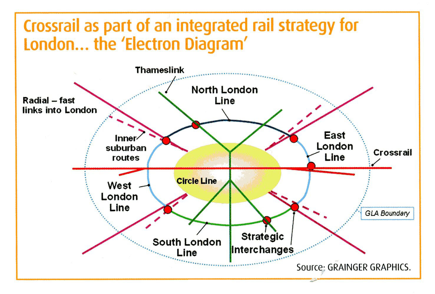
Whilst passengers likely treat Crossrail and Thameslink as long distance and/or express Tube lines, TfL considers the former to be a new mode. As such, shouldn’t this faster, more spacious, cross-London longer distance line be visible as higher hierarchy travel on TfL’s signature map?

The chances are that a person taking Thameslink will transfer to one or more TfL services – mobility works better as a network, not individual lines. As Albert Stanley’s 1907 implementation of coordinated fares throughout all of London’s Underground railways demonstrated, providing free transfers between lines increases ridership.

How to fix this

At a distance, both Crossrail and its north-south older step-brother are almost invisible on the current Tube Map. Some TfL maps show Elizabeth as hollow purple, which does not cut through the map clutter. On other maps the Elizabeth line is solid purple, which is much clearer, and should be standard for all of the authority’s maps. This demonstrates how ‘low in the mix’ they are, as a music producer would say. These lines need to be more visible than the lower capacity Underground lines.

Passengers don’t really care that it’s “not a Tube line”, which apparently is why TfL made it a hollow purple line. As we explained, passengers are using it as a Tube line, and are already referring to it as one.

Good design needs to keep up with new circumstances. The Elizabeth Line’s opening adds a new strategic high capacity, express corridor, and needs to be prioritised visually as a new east-west trunk of the capital’s rail public transport network. Correspondingly, Thameslink also needs to be equally visible and prominent as the north-south trunk line.

The following map from the LR Crossrail 2 Part 2 article shews what a more emphasised Elizabeth line could look like (as well as the planned Crossrail 2). Thameslink, on the other hand, isn’t even as prominent as the Underground lines:

Crossrails 1 & 2 with emphasis. jrc

Thameslink’s dashed, hollow line, weaves and ducks through Tube lines like a striker zigzagging through an entire defence. It’s suburban line camouflage, lost in the thicket of Central London lines. Which may well have been the intention.

To make it more prominent, it may be worth looking at its previous incarnation – as a hollow black line. This holds its own against the solid Underground lines when looking at the Map up close, as we saw in the 1998 Tube Map at the top of this article. And it is chromatically consistent with the similarly north-south Northern Line. But the clarity of hollow lines is sometimes lost in the overall view of the Map. Perhaps a solid colour would be best for Thameslink, although the easily distinguishable TfL line colour palette is close to reaching its end game.

It needs to be noted that making lines thicker causes many problems in the geometric relation of interchange rings. Jonathan Roberts (JRC) is his map above made his Crossrail 1 and 2 lines thicker to make quite visible, not as an actual suggestion for the Tube Map. We reproduce this map with the same intent – not as a suggestion. However, there are several ways of differentiating lines (and interchanges) and they all come with their own compromises. Thickening a line is only one of them.

Other Tube Map thoughts

TfL expects a large interchange of passengers at Farringdon at the core of the high capacity network, bringing a lot of new passengers to TfL services from outer London. Unfortunately, there is generally poor awareness of Thameslink of those not in its service area. No doubt in great part due to TfL exiling its rival urban railway from the Tube Map between 1999 and 2020.

It is possible that TfL also allowed the central section of Thameslink to appear on the pandemic map as an experiment to see if it helps grow its own Underground ridership. Additionally, airport connectivity from outside Zone 6 might also become a new market for Farringdon interchange, given the journey time reductions via the new trunk route network. To wit, Farringdon is the second London urban rail station to provide direct connections to three of the London airports and to Eurostar, after King’s Cross-St Pancras.

TfL may also be keen to reduce interchange at Tube interchange pressure points by having Thameslink on the map, to avoid spending billions on upgrades at busy Underground stations such as Kings Cross-St Pancras and Finsbury Park. TfL is also considering including other Network Rail metro services onto the Tube Map to address the apparent lack of rail transport in south London and in some parts of north-east London.

Positives, and negatives, of the new Tube Map

The new map is messier than it should be, due to Crossrail’s temporary three section operation. Once Elizabeth through trains start running in autumn, its line will be straightened out.

Thameslink has many fully accessible stations with level access to the Class 700 trains – so having Thameslink on the Map opens up many journeys for disabled and mobility challenged (with prams, luggage, pushchairs, bulky items &c) users.

Thameslink – Crossrail fare integration problems

Surprisingly, given the massive work that TfL has put into integrating Crossrail into the Tube network, some Thameslink passengers have been experiencing fare overcharges. Those passengers coming from beyond the Pay-As-You-Go fare payment area found that they have been charged the maximum Zone 6 fare when changing to the Elizabeth line at Farringdon. TfL then realised the problem, and had staff instruct such passengers to leave Farringdon station, re-enter, and tap in again to be charged the correct fare. The short term issue is missing fare validators. Apparently, TfL didn’t believe that such distant Thameslink passengers would transfer to the Elizabeth Line in appreciable numbers.

TfL then issued a Media Briefing acknowledging the issue, clarifying that this occurs for Thameslink passengers originating outside the PAYG purview. The London authority is working on a more permanent solution, but in the meantime suggest that transferees touch in at the fare barrier line or at the Underground platform validators. Furthermore, TfL will be installing additional signage at Farringdon, as well as locating more TfL Ambassadors at this station, to assist. Online amending of the journey or contacting TfL Customer Services are also means by which passengers can correct the fare error.

Some passengers have noted that TfL limits users to only three online fare corrections per month, but this has not been confirmed. Diamond Geezer goes into more detail on the missing validators issue.

Mayor Khan, Tear down this Thameslink wall!

Nevertheless, to maximise public transport ridership in these over-driven, over-polluted, and over-Uber’d times, both regional express lines need to be on the Tube Map permanently. And prominently.

Let’s hope Mayor Khan does what his predecessor did and push for a complete integration of Thameslink on all TfL maps and signage.

Epilogue – We are not yet post-Beck in Cartoland

We are likely stuck with the Tube Map for the foreseeable future. No-one has come up with a better design, and there is over 90 years of instant recognition and familiarity with the Beck-based design. Simon Garfield’s book On The Map claims that the Tube Map has “In its various forms… been printed more than any other map in history – perhaps half a billion times”, presumably including personal printing. It is instantly recognisable, even without any text:

straw tube map. kyle bean

The map has also spawned many imitations and variations for other cities, railways, non-public transport networks, as well as parodies and art works, such as The Great Bear:

The great bear (1992), detail. Simon Patterson

As TfL makes considerable revenue from licensing the Tube Map image on hundreds of products, and the Tube Map is one of graphical icons of London, it does not appear that this map design will be replaced anytime soon.

Royal mail

Whilst the Tube Map is far from perfect, and has been subject to decades of compromises as lines, interchanges, modes, and information have been added, it is not likely to be replaced for a long time yet. Which leaves the way forward as make do and mend.

Thanks to NotQuiteTangible.blogspot.com for his brilliant Crossrails 3 map.

We shall brook no discussion of redesigning the Tube Map, as that’s a far larger scope, with no urgency at TfL to consider it.

44 comments

  1. Very interesting article, and seeing the choice of header image was a fun surprise!

    When the article writes “ignore the pink northeast to southwest Crossrail 3 line” – I think this should say “turquoise” instead of “pink”, or “Crossrail 2” instead of “Crossrail 3”, since on that map Crossrail 2 is drawn in pink and Crossrail 3 is drawn in turquoise.

    [Cheers! I’ve corrected the ‘Crossrail 3’ reference to be ”Crossrail 2. LBM]

  2. “Apparently, TfL didn’t believe that such distant Thameslink passengers would transfer to the Elizabeth Line in appreciable numbers” I’m one of several who come in from North Herts and commute to Canary Wharf. It’s not an unknown journey, I’ve filled in many a passenger survey over the years!

    Elizabeth line has shaved 10 mins off my commute and is getting steadily busier, but the faff of going out/in at Farringdon is annoying and I’ve already accidentally tapped out with the wrong card once. I use PAYG now as do so many more people doing hybrid working, pre-pandemic I had a season ticket which wouldn’t have needed validating as it would have covered me for the tube. Not having platform validation when they do have them at the tube cut through was very short sighted of TfL.

  3. “with no urgency at TfL to consider it”
    Well that’s tremendously disappointing, and I’m going to my own thoughts there.

  4. It’s interesting that there are several key inside-London routes that are missing from the Tube map:

    The first of these is illustrated by the inclusion of the Ikea sponsorship logo on the Tube map at Tottenham Hale. When, of course, the station is Meridian Water, two stops up the invisible line.

    The missing line between Tottenham Hale and Stratford (via Lea Bridge) directs Tube Map users to go via Highbury & Islington, which takes 45 minutes, rather then the direct 10. It’s got a 4th service, don’t you know. Of course you don’t.

    Other missing routes are the C2C fast connection from 100% missing Z1 Fenchurch Street station to Upminster only stopping at Limehouse, West Ham and Barking and all which are done at normal TfL charging.

    And as a long-term commuter from Brighton, not being able to see that you can get from East Croydon to Victoria via only Clapham Junction seems a terrible lie.

    Another possible lie is not showing the fast Marylebone to Harrow-on-the-Hill, and then fast again to Rickmansworth and all Met stops to Amersham. It’s a much quicker way out to Zone 9.

  5. Can I be the first to suggest that the Liz Line will go solid purple on the Tube Map (as it is already in the trains, and the in station diagrams and “London’s rail and Tube services”) when the full service (Shenfield to Paddington and Abbey Wood to Heathrow) starts (on Saturday 10 December 2022)?

  6. Third thought: Given that it connects just two stations but uses up a whole colour, why not make the Waterloo & City a “white line with black outline” again and use the “toothpaste green” for Crossrail 0/Thameslink?

  7. Some years ago, when the lifts at Kings Cross St Pancras serving the Circle, Met, and H&C lines were unavailable for an extended period, TfL advised passengers requiring step-free access to get a bus between Farringdon and Kings Cross St Pancras. Early in that particular period, I wrote to TfL pointing out that it would be much easier for disabled passengers to get the regular Thameslink service between those two stations (the Thameslink platforms at St Pancras Int’l had working lifts during this time), and that TfL really should mention that option with at least equal prominence. They replied to me that they were simply trying to give choice, despite neglecting to mention anywhere the simplest and most obvious option. And, for the following months, I saw no amendments to the signs around Kings Cross St Pancras station, all of which were advising passengers requiring step-free access to get the bus without mentioning Thameslink at all.

    I even overheard a TfL employee trying to explain the bus route to a disabled passenger, without referring to Thameslink at all. I can only assume that TfL wanted the bus-fare revenue instead of sharing the train fare with Thameslink (the gateline for St Pancras Int’l Thameslink platforms is separate from the Tube, so the system would be able to allocate revenue to Thameslink very easily and fairly, I would imagine), and did not care a jot for making the journeys of disabled passengers convenient. This is not to say that buses are bad (indeed, I can imagine a situation where the bus option could be better, *if* the final origin/destination is near an intermediate bus stop between Farringdon and Kings Cross), but it is absurd to imply that a bus route is the only step-free option when a convenient and frequent rail option also exists.

  8. As a long term user of the Northern City Line, its banishment from the tube map was always an irritant. No one wanting to travel from Moorgate or Old Street to HIghbury & Islington or Finsbury Park and points north & east on either of the blue lines would consider going via the Northern Line to Kings Cross, especially as the trains have air-conditioning.

    Now it provides a connection to the Elizabeth Line which isn’t available for either the Victoria or Piccadilly Lines’, it absence is even more annoying (though so is the extra charge for going that way to stations west of Farringdon).

  9. Having been on the periphery of TfL map discussions in the past, I genuinely think that omitting useful central London shortcuts from the “Tube” map isn’t a calculated attempt to maximise revenue. There’s just a rigid and arguably outdated view that it’s a TfL map and should only show TfL services. Adding the whole of Thameslink with all its branches (surely not what the campaigners really wanted even if that’s what they said) was a petty attempt to say “told you so” when it inevitably ended up looking confusing and still didn’t help with similar shortcuts such as Moorgate-Finsbury Park or Charing Cross-London Bridge).
    (and a member of staff on the ground explaining the best route to a passenger really isn’t worried about making sure TfL get the bus fare rather than Thameslink taking a cut.)

  10. @Andrew S

    Interesting insight. By why is it that Tfl doesn’t show the non-TfL shortcut routes between Underground stations you cite (Moorgate-Finsbury Park, Charing Cross-London Bridge) on the Map? What are TfL’s policies for line inclusion on the Map?

  11. At last! A London Reconnections article that’s actually about London!

  12. There’s definitely still a problem with the implementation of showing thameslink on the tube map, that being the stations north of Finsbury Park on the GN. Those see about 3 trains a day in the peak direction, which isn’t particularly useful. If the GN & C was shown then that would make more sense and thameslink could be removed from those stops. Especially given that contactless is available to Hertford North and Welwyn Garden City.

    It just feels like a bit of extra thought needs to be put into how these kinds of services are added than has been done with thameslink.

  13. There are a few assertations of TfL thinking, “TfL cartographers have begrudgingly added these to the Tube Map”, are these known or guesses?

  14. Thameslink as Crossrail 0 is a lively concept.
    The name Thameslink itself is really quite nice.
    Though I wonder, if it had been called a ‘Line’, it might have been welcomed into TfL family. (trouble is, like Overground, it has many lines and spurs, so is confusing)

  15. “In the fall”? What is this, are we pre-empting a further plunge in the fortunes of Crossrail delivery in the autumn?

    [Corrected to autumn. LBM]

  16. @Toby Generally speaking, TfL and its predecessors haven’t liked to add rail lines to the Map that it itself doesn’t operate, to avoid additional ‘clutter’ (in addition to the revenue protection). North London boroughs campaigned hard to have the North London Line added to the Map in the 1970s, and it was sporadically removed and reinstated from the Map up to 1999. Similarly, the Northern City Line had been removed in 1999 as well, and hasn’t been restored since, despite once having been a part of the Underground network for most of the twentieth century.

  17. @glbotu Certainly the Moorgate to Finsbury Park section on the GN&C (aka the Northern City Line) could well be added to the map, with services heading further north illustrated with an arrow, as the rest of the Thameslink network is indicated.

  18. “To wit, Farringdon is the second London urban rail station to provide direct connections to three of the London airports and to Eurostar, after King’s Cross-St Pancras.” If we were to include all of it’s stations (like with King’s Cross-St Pancras) then Woolwich Arsenal/Woolwich (EL)/Woolwich (NR) would be the third once the Elizabeth Line is fully connected – pretty impressive for a Zone 4 station!

  19. @Brian Butterworth
    London has six international airports: the five you named (City, Heathrow, Gatwick, Luton, Southend) and Stansted.

  20. I think they missed a trick by not calling the new line Elizabeth *Link*’ to match Thames *Link* to show that it’s not quite LU. Perhaps they can bear it in mind when Crossrail 2 is formally named.

    PS has anyone having problems with Norton marking LR as ‘Unsafe’?

  21. Yes, my work firewall is very unhappy with the London Reconnections site.

  22. Compared to the Elizabeth Line, Thameslink is a car crash of routes. In recent years the line now offers services North to Bedford, Cambridge and Peterborough whilst the South to Brighton, Orpington, Sevenoaks, Rainham(Kent), Horsham and the Sutton loop too. I work at a station in South London on the latter destination where there is a frequency of 30 minutes and from experience cancellations are regular occurrence which inconveniences PAYG Oyster card users who are out of pocket for touching in. Whilst Thameslink offer such services they shouldn’t be on the current Tube map.

  23. “No-one has come up with a better design”

    I differ. There are some interesting contenders, not least from intat.fr but also one or two in projectmapping’s repository of alternatives.

    Other things made a nonsense by the TfL-only diagram include the hidden fact that Vauxhall to Wimbledon is a fast high intensity 3-stop metro service that takes mere minutes. The all rail services map needs to be tidied up and and we would be a lot better off without the tube map. After all, TfL had no hesitation in ditching the bus map!

  24. Related question. Does the TfL journey planner correctly recommend using the Thameslink/Northern City etc. when it is the shortest/quickest/most step free? Ideally without needing to reset any default options (except step free). Clearly the journey planner should (revenue protection be damned).

    Also worth comparing to other journey planners e.g. Citymapper, Google,etc. to see if the others do recommend using Thameslink etc. correctly in cased where TfL does not.

  25. Isn’t what many are asking for here already available – The London Tube and Rail map.
    Or National Rail’s All Stations Train Operator Route Map if you prefer a (slightly) more geographically accurate map, and all of England, Wales & Scotland.

  26. @Neil – absolutely! I’ve yet to see any argument that justifies the continued inclusion of Thameslink on the Tube Map, rather than the further elevation of the Tube and Rail map as the TfL-preferred map for navigation. If I was, say, SWR or Southeastern, I’d be peeved that Thameslink got free advertising from TfL, justified by reasoning that would also apply to my network!

    I say further elevation of the T&R Map, as it is already the default on the TfL website, and the map on every TfL platform (the Tube Map is missing from some). It’s just those Central London maps in tube carriages that need conversion, and paper T&R maps produced. I’m ignoring teatowels, jigsaws, etc that are the main reason why the TfL-only (plus, inexplicably, Thameslink, including tentacles, and nothing else) Tube map still exists – a bit of brand merch (which arguably the pocket maps are).

  27. Coming back to “what is the map for”, I guess one purpose is to illustrate where Oyster and contactless fares may be used. Travelling on the tube last week I overheard two people aged around 30 with one person explaining to the other that his “tube” travel card was actually valid on buses too and on “Network Rail” in the same areas as the tube goes. This was an approximation that explains there’s no real collective term for all transport modes in the “greater Greater London Oyster area”. This implies that parts of all the suburban operators’ networks should be shown on a map, but probably not named the tube map!

    I guess this will become even more important as another 200+ stations in this area, probably better termed the Home Counties are to be enabled for contactless travel.

  28. Many ‘opinions’ so mine are:
    Traveller NEED is for three fundamental maps Inter-city, Suburban (Network SE/Connections), London Metro (min 4tph).
    Marketing / Historic Beck imagery
    Supplementary uses : route planning, interchanging, toilets, ticketing

    There is no definition of the London Metro or London or Metro. The original London Underground Railways used the solid colour highlighting of their services on an overlay of feint other lines and features. Beck’s 1933 map did not include the London SW Underground Railway – it was added in the mid 30s as an ‘other’ service in black by LPTB when evaluating a Blackfriars interchange. The Waterloo & City line did not gain a colour until transfer from BR in 1993.
    I have no problem with the ‘London Underground’ becoming busier over time as the system has grown like in most cities.
    Usefulness is a feature of clarity. London’s political complications of operators and ticket validity should be on the supplementaries.
    My requirements are all rail services at fare zone rates with 4tph principally in Greater London around Becks solid colour trademark.

    Map of services ‘crossing’ central London justifies TL & Xrail but not the Liv St network. Clapham to Watford Junc would be included if the frequency was 4 instead of 2. ‘Infrequent’ services like Olympia or Ongar have been shown in dashed tone with the spear so that option remains. Same with Premium services like HeathrowX or Stratford Intl. (Diamond?). Dashed outline routes are an option.
    The Greenford shuttlle should have the same treatment as the Upford/Romster.
    Connections / route / symbols are missing for London Stanstead and London Southend.
    Areas of London with a 4tph metro service omitted from the map are done a disservice for connectivity – some southern, GNCity and C2C. If terminating just outside the boundary show it like Shenfield but both should indicate the direction of onward service not just the symbol. Slough to Reading is not really justifiable although it achieves 4tph in combination with other services.

    The map does a good job with an ongoing debate about content, what should be added or deemphasised for clarity.

  29. @MilesT: From experience Google Maps’ journey planner does direct you to use the Northern City Line / Thameslink when it’s quicker.

  30. @Perias Pillay

    Of course.

    @Aleks

    The in-car cropped Tube Maps seem to have a strange problem that makes them really hard to read. Taking Stratford as the top right hand corner of these types of map. Trying to just scan how to get to (as an example) Liverpool Street there are so many complications to scan past. For example one of the the two Bethnal Green stations (the Central Line one) is shifted up to avoid the Liz Line to Abbey Wood to make space for the Liz Line junction that **will appear** left of Whitechapel though the gap between the words “Bethnal Green” and “Mile End”.

    I just makes trying to scan this area of the map very hard. Which station does the Shenfield Liz line connection blob actually belong to? It’s closest station name is Old Street, it’s directly connected to Moorgate, but only guesswork finds the correct answer of Liverpool Street.

    And yet the same area doesn’t tell you that London Fields and Cambridge Heath don’t connect to the Chingford branch, you have to work this out from the red daggers.

    All from 2 meters away on a moving tube train.

    To quote Bladerunner: “this is a test designed to provoke an emotional response”.

  31. TfL is transport fo London. Non TfL lines are as much a part of London’s transport as TfL lines are. TfL had a central London map showing all lines, which was removed from their website during my dispute with GLA member Caroline Pigeon, who couldn’t give a logical reason for the inclusion of one non TfL line on the Tube map. They could have simply updated the all lines central map and it would have been useful. Not too large in print form and not lacking lines for reasons that must bewilder visitors.

  32. @ Brian Butterworth
    Probably not clear on my part. I was just stating that the phenomenon of a London rail station providing direct connections to 3 London airports & Eurostar will soon be followed by Woolwich once the Elizabeth Line is fully connected (Heathrow on EL; Luton on TL; City on DLR) – a big improvement given 20 years ago it only had 1.

  33. 100andthirty: Thinking back to when flat fares were first introduced as the “West End” and “City” zones, with an overlap in the middle, there was a thing called the “Capital Card” alongside the “TravelCard”.
    Anyone seeking to use the “walking connections” map will have fun trying to walk in the suggested direction from Swiss Cottage to South Hampstead! Geography doesn’t matter for trains so much but definitely should for walking.

  34. Apologies if this comment has been made already. The “Tube Map” is a misnomer as it includes modes such as Tramlink which isn’t a tube (although it does have a couple of tunnels) yet excludes the Great Northern & City Line, which is definitely a tube. It also include obvious National Rail connections such as Waterloo to Vauxhall. The “Tube Map” is iconic, but it’s no longer fit for purpose. Perhaps a version of it could be retained for tea towels, jigsaws etc. The “Tube and Rail Map” is comprehensive and hence very useful. But it’s also very big. I’d like to see a “Central London Tube and Rail Map” which covers Zone 1 and bits of Zone 2 – basically whatever comfortably fits in a pocket-sized rectangle. It would have arrows indicating endpoints and key destinations outside the area. This would be the standard map displayed in tube cars, tourist guides and other such places where space is limited. Stations would display both the Central London map and the big map. In short, passengers don’t care who operates the service – they care about where it goes to and from.

  35. AlisonW & 100andthirty My commuting years included the Capitalcard years. It was a major bonus in places like Putney where there were both tubes and trains but the tickets were not useable at both. The relatively small extra cost of a Captalcard Season rather than a Putney – London Terminals season made it a very good deal. There is a little bit of Capitalcard history here…. http://www.srpublicity.co.uk/brs/capitalcard.htm

  36. @David Bleicher

    If we’re picky about this, the Met, Circle, H&C and District line’s aren’t “Tubes” either, they cut-and-cover construction has an arched profile. Only things constructed with a “Greathead Shield” are tubes, the oldest bit being the London Overground between Wapping and Rotherhithe (1825-43).

  37. Now that Thameslink is back on The Map, perhaps the automated announcements on Thameslink trains will acknowledge the existence of the Elizabeth Line at Farringdon.

  38. @Brian Butterworth Very good point! Perhaps the Tube Map should exclude the Piccadilly Line west of Earls Court and north of Bounds Green, but include the bits under Heathrow Airport. Oh, and that bit around Southgate too.

  39. @David Bleicher – You can just Google “tfl tunnels map” to get that map as there there is an official one!

    @John M – see also Greater Anglia who are still calling out “TfL Rail” for both interchanges and status boards at Liverpool Street, Stratford, Romford and Shenfield.

  40. @Brian Butterworth – I think you made a good point earlier about the mini W & C line hogging a whole colour and should be made a ‘white line with black outline’ again. But perhaps the turquoise could more usefully be reserved for one of the branches of the Northern line when the anticipated split occurs in the not too distant future .

  41. Typo:

    “…TfL exiling it’s rival urban railway…”

    should say:

    “…TfL exiling its rival urban railway…”

    [Corrected, cheers. LBM]

  42. I deprecate the increasingly common reference (official, alas, as well as public) to the entire London Underground being called the ‘Tube’. As Brian Butterworth says, the sub-surface lines should not be called ‘Tube’ lines. But I would argue that construction using a shield (as with the Thames Tunnel) is not the determining factor as he suggests. Surely it is the reduced bore and stock size that matters, so the further reaches of e.g. the Piccadilly Line are still ‘Tube’, although running on the surface? (I stand well back, ‘minding the gap’, and wait for someone to suggest the exception that disproves the rule.)

Comments are closed.