
Letters from America - Part 1
A potted history of transport in London and New York City (NYLON)
Having been born and raised just outside of New York City, but spending most of my professional transport career in London, returning to the USA and NYC after 22 years away has given me a unique perspective on both cities. This will be the first of a series of 21st Century, transport themed ‘Letters from America’ which will try and highlight some of the most interesting differences in transport policy and provision between the two countries who are separated by an ocean and a common language. This will be very much a personal view but grounded in historical and current evidence.
Historical Context
First, it is worth setting out some historical context of the two greatest cities in the world. There is far more transport related history of London and NYC which could fill volumes of books. A perfect example of how London and NYC have intertwined transport histories is the tweet that the NY Metropolitan Transportation Authority (MTA – NYC’s TfL) linked to the 150th Birthday of the opening of the first London Underground line in 2013 – ‘Happy Birthday Big Brother’.
However, the rise, fall and rise again of these two great cities since 1800 is very much linked to the scale and quality of its transport system as you will see. Much of their growth in the 19th Century would not have occurred without two key changes; the Industrial Revolution; and invention of railways and their evolution from primarily moving goods to transporting people to/from jobs, education and leisure.
In the States, the goods function remains the railway’s primary purpose outside ‘megalopolis’ urban zones such as the North East Corridor, as airplane has supplanted rail as the dominant long distance public transport mode and the ‘freeway society’ has undermined shorter-haul rail travel.
Early London
London was established in the period after the Claudian invasion of 43AD, due in part to its location along the River Thames, providing easy maritime access. It was also the first practical crossing point of the river. From that time, London became the most important regional centre in Britain. It grew to a population of nearly 1 million by 1800 and was the largest city in the world through to well into the 20th Century, with 8.5 million population in 1939. New York then overtook it.
While London became an industrial centre, it was always less dependent on manufacturing than other British cities such as Birmingham, Manchester or Glasgow. Commerce, and London’s role as the political and cultural capital of the nation, required new ways to travel as the city’s streets became increasingly congested, and as Britain’s previously rural and semi-feudal society became urbanized and in social terms moved towards a more emancipated 20th Century.
While originally envisioned as a way to get goods to their immediate destinations more quickly and effectively around the north of England, in terrain often unfavourable for canals, railways were a more efficient transport mode and rapidly grew in importance throughout the country for people and goods. Various private companies competed to deliver railways into London, which was one of the biggest causes of the capital having multiple termini on the edge of central London.
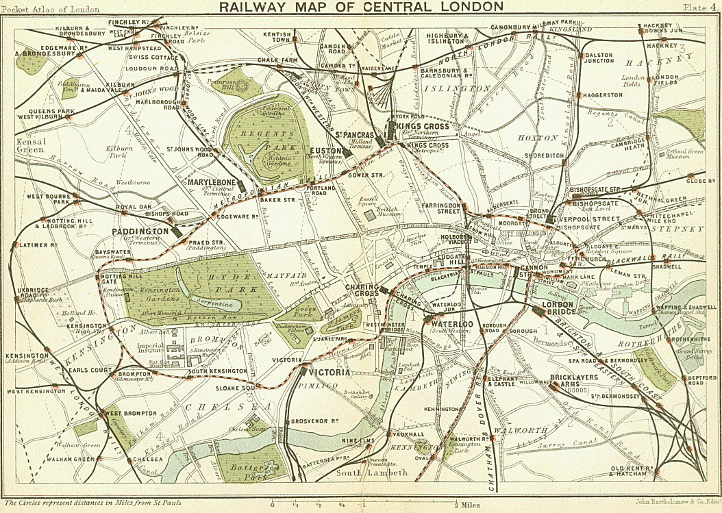
Many of London’s main line suburban branches were in place by the 1870s, to the fringe termini and/or direct to the City. By the same period, London had expanded within much of what we now know as Zone 1, and was creating or enlarging suburbs in parts of Zone 2. The lack of direct access to London ‘proper’ led to slow and complicated local journeys.
The opening of the first section of the Metropolitan Railway in 1863 quickly showed that railways could transform how people moved around the urban area, subject to large-scale capital investment. The ‘Met’ also became the western and northern termini’s access to the City.
Early New York
New Amsterdam was established by the Dutch in the early 17th Century, as a trading post. Renamed New York when control passed to the British, its development (like that of London) was linked to its good access to inland and ocean maritime routes. It cemented its role as the most important city in America during the War of Independence in the late 18th Century and in its aftermath when it was the first capital of the USA. As with London, New York City’s growth in the 19th Century was linked to the country’s growth, due to the city’s role as the national finance and legal centre during the Industrial Revolution.

Most of the city’s population was concentrated in lower Manhattan Island, within walking distance to the rivers, until after the American Civil War in the 1860s. Ferries were a vitally important means for people and goods to travel, constraining the ability to grow in areas considered remote to ferry landings.
The introduction of streetcars and then elevated rail lines (Els) across the city, first opening in Manhattan in 1868 and Brooklyn in 1877, helped to allow the city to grow away from the riverfront. The Els helped to spur development up Manhattan Island, along the grid system of avenues which was adopted during the 19th Century above Houston Street (the border of much of the city’s population at this time). However, the Els were intrusive, both visually and in terms of noise and air pollution, which was only partly remedied when the lines were converted from steam to electric operation.

While NYC also had multiple rail termini outside the main commercial heart, driven by different private rail companies, another factor was the challenge of crossing the East and Hudson Rivers. Commuting by rail was a smaller proportion of total demand compared to London during most of the 19th Century. The main exception was the New York Central Railroad and its predecessors, which connected northern New York state suburbs directly into Manhattan, with its termini first on 14th Street, then 26th Street and eventually Grand Central Depot in 1871 at 42nd Street (the current Grand Central Terminal opened in 1913).

Into the TWENTIETH CENTURy
By the end of the 19th Century there was a clamour in New York to build underground rail lines to allow the city to continue to grow away from downtown Manhattan, connect the newly amalgamated boroughs (in particular Brooklyn which joined with Manhattan in 1898) and reduce the negative impacts of the Els. The rapid introduction of electric traction also made underground rail services a practical proposition, as was the amalgamation of the numerous Els and other railroads during the 1890s.

In 1900, the city approved construction of the first subway line to a private company, the Interborough Rapid Transit Company, which was financed and led by August Belmont, also famous for his role in opening of Belmont horse racetrack. The first 14.5km section opened in 1904, and the line was notable for its four track layout right up Manhattan – with centre track express trains, and local trains on outer tracks.
Much of the London Underground sub-surface network had opened or was under construction for steam haulage in the 1870s-1890s, with electrification beginning at the turn of the century. Across Europe, initial urban rail networks were constructed including the Mersey Tunnel, and the Berlin and Vienna Stadtbahns. Opening of the first metros (and in London the deep-level tubes) took place from the 1890s and 1900s, with Budapest and Glasgow in 1896, Paris 1900, Berlin U-Bahn 1902.
The construction of London’s deep-level tubes accelerated the expansion of London’s second urban core, the West End of retail and leisure facilities, north of the main national administrative district, Whitehall and Westminster. After the City’s bombing in 1940, many offices also moved to the West End.
As with much of the national rail network, the Underground was largely built by private companies, with the most influential leaders being a tale of two Charlies, with Pearson supporting and financing the construction of the early Metropolitan Railway, and, later, Yerkes financing tubes through the West End.
Largely because of financing problems, moves were undertaken to amalgamate most city-specific rail services and feeder trams in the years before the First World War. The largest city bus operator, London General Omnibus Company (LGOC), was also absorbed. Known as the ‘Combine’, the holding company was the Underground Electric Railways of London (UERL) and for several decades was the primary force in centralising transport organisation and finance.
Key drivers of this amalgamation of disparate transport services were Albert Stanley, initially the Managing Director and later Chairman (as Lord Ashfield), and Frank Pick who over time effectively became the organisation’s chief executive.
Albert Stanley had lived many years in America and had been instrumental in the development of the streetcar network in New Jersey, just outside of NYC, until he was invited to London by American financial interests as a successor to Yerkes during a period of funding instability. Under Ashfield and Pick, the UERL, and the 1933 ‘London Transport’ (LT) successor (see below), continued the transformation of unified services and facilities towards a high-quality network.
Amongst the achievements began by the UERL were extensions of the Underground network, simpler fares and contemporary branding and designs, ranging from the famous Harry Beck tube map and the Roundel, to Charles Holden’s iconic Underground stations.

While it was the Metropolitan Railway which established ‘Metroland’ communities around its own suburban stations, the UERL achieved similar outcomes, as did the Southern Railway. ‘Semi-detached London’ was the memorable and generic land use outcome, along with LCC housing estates. In total, these are some of the earliest examples of planned transit-oriented developments in the world, albeit at lowish densities which didn’t fully reward the fare box costs of the extensions!

Developments by WW2
Growth of London’s transport network continued through to the start of World War II. The pre-WW1 merger of some city transport operators had proved insufficient for a stable base for funding and planning. Eventually there was a large-scale merger in 1933 of rail, tram and bus services within a 20-30 mile radius, with the formation of the London Passenger Transport Board (LTPB) – popularly known as ‘London Transport’ – having the UERL businesses at the core.
Main line suburban services were the only exception, although there was a Standing Joint Committee for these and LT to pool and redistribute revenues, and to plan the shape of future rail services. A large government-backed share issue was offered in 1935, for a £40m (worth approximately £24bn today) investment in railway capacity relief and expansion. Separately, the Southern Railway was investing in electrification, also with government support.
Importantly, LTPB was a quasi-public company, similar to a public utility, which had autonomy and a monopoly of transport services within its area, other than those provided by the Big Four private rail companies.
In NYC, the network also grew rapidly either side of World War I, through what was known as the ‘Dual Contracts’ connecting four of the five boroughs by two private companies, the IRT and Brooklyn Manhattan Transit (BMT).

Rapid growth in population and jobs followed including the urbanization of Harlem and other previously separate communities as well as the creation of a second financial and legal centre around Grand Central and Pennsylvania Railroad (Penn) main line stations – or ‘Midtown’.
As in London, public influence and control of New York’s transport network began to be felt during the 1920s with the construction of the city-owned Independent Subway System (known as the IND), which started services in 1932. Most of the current subway network was completed by 1940, while ferry, Els and streetcar services diminished. Despite the Great Depression of the 1930s, NYC continued to see rapid growth.
WWII and the decline of London & NYC
Before the start of World War II, both cities had begun to consider new forms of transport investment. The question was what to invest in, where.
London regional authorities such as the London County Council and Middlesex County Council had long favoured a twin investment programme, in roads as well as rail. The £40m New Works Programme (1935-40) upgraded Underground stations and extended some tubes to relieve bottlenecks, as well as electrifying suburban rail services and creating more capacity for additional outer London housing developments..
There were detailed discussions between Lord Ashfield and the Treasury in 1938-39 about a second New Works Programme to follow in 1940, what it would cover, and how it would be funded. Specifically, it was intended to cover the underfunding gap (around 12 per cent) in the 1935-40 scheme, finish the conversion of South London trams to trolleybus, and build more tube extensions. But the war changed those priorities.
In London, the combination of the death of Lord Ashfield in 1949 (Frank Pick having been dismissed in 1939 and died in 1941), the need to repair the damage of WWII, plus a new Labour Government’s ambition to nationalise critical industries such as the railways and other privately-owned passenger and freight transport companies (1947 Transport Act) constrained LT from finishing its ambitious plans. The Green Belt (below) also constrained city expansion.
Civil servants in the Ministry of War Transport were scathing about the need for and affordability of public transport expansion plans devised by London planners and the rail industry, and this attitude continued post-war. The failure to authorise a transit link or main line to the new Heathrow Airport in the mid-to-late 1940's is one example. Instead, Bressey and Lutyen’s arterial roads plans (1937), and Abercrombie’s from the 1944 Greater London Plan gained ascendancy, along with associated town planning priorities along with a Green Belt around London (1947 Town & Country Planning Act).
Unfortunately for London, the Labour government nationalized LPTB and the main line railways after the war via a single financial organisation, the British Transport Commission (BTC). The London Transport Executive was included in the BTC. While Ashfield had ensured that the new BTC began life in LT’s 55 Broadway offices (so tried to give a tactical policy advantage for his LT), London Transport itself counted for little compared to the nationalised railway’s costs, accumulated maintenance debts and inadequate revenues.
During the same period, the hollowing out of inner London’s population to the new towns being built around the city, and post-war ‘slum clearance’ policies (what ‘slums’ were left, ‘full circle’, became desirable dense inner housing by 2000!), started to put real pressure on London Transport. First there was falling demand as there were fewer people per square mile; secondly, people became less reliant on public transport in car friendly communities; thirdly a workforce found more attractive alternative employment in factories located in suburban London or the new towns, which had poorer rail links.
In addition, UK Government policy in the 1960s shifted numerous public office jobs from London to other parts of the country. Out of necessity to maintain public transport staffing levels within London, from the 1950s there was also recruitment by London Transport, in the West Indies, Indian Sub-continent and parts of Africa, which along with post-colonial factors started to re-shape London and other cities in Britain, with new demographics.
In NYC, transport investment shifted to non-rail infrastructure under the leadership of two transport master-builders and rivals; Robert Moses as head of the Triborough Bridge and Tunnel Authority (amongst other responsibilities including NYC parks), and Austin Tobin who was Executive Director of the Port Authority.
Between these two master builders, much of NYC’s key non-rail infrastructure was constructed - all three major airports (LaGuardia, JFK & Newark), key roads including the Lincoln Tunnel, Verrazano Bridge and parkways/expressways crisscrossing NYC, as well as the United Nations and World Trade Center developments.

While some of these road projects had started before WWII, progress accelerated after the war. Much of the new road infrastructure came at the expense of transit, sometimes replacing previously planned subway line extensions, and preventing transit lines from being constructed alongside the new roads. – there are numerous books which provide more detail on these two master builders:
- The Power Broker: Robert Moses and the Fall of New York, Robert Caro, 1974.
- Robert Moses and the Modern City: The Transformation of New York, Hilary Ballon, 2008.
- Perpetual Motion: The Illustrated History of the Port Authority of New York & New Jersey, Joe Mysak, 1997.
While it is clear that the changes in transport investment from public transport to roads and airports were not the only factors, both London and NYC saw their population and their economic importance fall in the post WWII period. Both the densities of London and NYC fell, and the majority of new jobs created were in auto dependent locations. NYC in particular, saw the rise of suburbia, linked to a de-population of cities into car designed suburban communities, of which the Levittown developments are the best known. Jobs followed, clustering around interstate highway interchanges.
The NY edge cities included such commercial hotspots as White Plains (headquarters to IBM), Stamford, Connecticut (which hosts head offices for 17 Fortune companies including Aetna Insurance) and the Parsippany, NJ area (headquarters to a number of large firms including Avis/Budget). The shopping mall revolution was also designed around the car and was sometimes were openly hostile to public transport, turning their backs on local bus services and locating bus stops beyond surface car parks.
Public transport networks suffered from these changes, with declining ridership, plus rising costs through a combination of a more competitive job market and increasing union power. This was combined with a lack of government commitment to fund even vital maintenance and renewals. From a peak just after WWII, London Underground saw demand fall from nearly 800 million to less than 500 million annual trips in 1982, with an even more significant fall on London’s buses and the demise of its tram and trolleybus network (once the world’s largest).
Similarly, NYC’s system saw even larger declines, with fewer than half the number of subway trips than the 1947 peak of just over 2 billion to 995 million in 1991. The combined effects caused a vicious circle of service cutbacks, maintenance holidays and poorer reliability, becoming a symbol of the cities’ troubles, most graphically with the regular subway fires and graffiti across the NYC subway network during the 1970’s.

Commuter rail services were not immune, with the thinning of London inner urban services by British Rail (though outer suburbans were improved), as well as the hollowing out of passenger rail services in the USA, culminating in the bankruptcy of Penn Central and other NYC regional railroads in the 1970s, and transfer of remaining commuter rail services to public agencies.
So, what was going to become of London and NYC? As you will see in the next chapter, the tide was about to change…
Co-author of this article is Jonathan Roberts, who wrote the London sections.